Wednesday 26 March 2014

Will's Walk - Day Two

Knitwits Yarns knitwitspenzance.co.uk

Well, Saturday dawned bright and sunny and, fortunately, the wind had died down a bit too.  Thanks to the wonder of modern anti-inflammatory medication Matt's knees and hips were recovered and we were able to crack on after a great breakfast here:

 We were joined by Will's aunt Mary, who had walked the first leg last year and now wanted to complete the whole thing a year later:

We set off at a goodly pace to Penzance, Newlyn and Mousehole (almost entirely flat for a pleasant change) with a minor pause to put on waterproofs when the heavens' opened.  The poor old Jubilee Pool in Penzance is looking very battered after the recent dreadful storms.  Here is their page giving information about how you can help save this iconic lido:


but it's always nice to be able to look back and see how far you've come:

The fishing boats in Newlyn harbour were looking wonderfully colourful:

and the sun came out so we could enjoy a pasty lunch in Mousehole:


The first strenuous part of the day was up Raginnis Hill out of Mousehole:

and thence on to the path to Lamorna Cove:

We made it to Lamorna in an hour, which we were pretty chuffed with:

and, again, the poor harbour wall has been badly storm damaged (although the controversial owners are receiving little sympathy in their bid for funding to repair it):


From there it was on to St Loy:

through beautiful grazed daffodil fields:

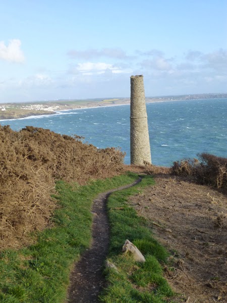
past Tater Du Lighthouse:

After St Loy we saw possibly the craziest allotment in the world - why? - how?:


and then the path became very up and down and we were walking right into the setting sun, which didn't help.  Down to Penberth, across this lovely little bridge:

and then right back up the other side!  From there to Porthcurno:

where we made the (sensible) decision to abandon the coast path and head inland on the road.  It was getting dark and we were getting knackered.  At the top of the Porthcurno road is this sign:

which depressed us no end.  a) because we'd taken all day and walked about 16 miles and, in fact, Penzance is just 9 miles away and b) because, it transpired, that the sign lied - Land's End was way, way more than 2.5 miles away - in fact we passed at least 2 more signs which also declared they were 2.5 miles from Land's End!

En route we passed this amazing post box in Polgigga:

which the observant amongst you will see says "VR" - Victoria Regina - which makes it pretty rare and well over 100 years old.

From there we flogged along for another 2 miles (at least) until we saw this very welcome sign:

As you can see, it was dark.  What you can't see is that it was also a bit damp and very cold!   Far, far away to our left we could see Lizard lighthouse flashing every now and then - quite incredible to think that we'd walked from there.

About 3 hours later (after we'd enjoyed a hot meal and a few drinkies):


the incredible, intrepid Truro College students arrived, supported by Cornwall Search and Rescue Team:


They were given a tiny lift from the coast path to near Land's End - not because they wouldn't have walked the whole way (they would) but just because they would have arrived at about 1am and their team leader (rightly) assumed we'd all want to be in bed by then!!

Their achievement was extraordinary and they should be justifiably proud of themselves - Ten Tors will be a doddle after this!

Next year we're thinking of doing it over three days (or leaving really, really early in the morning!).

RIP Will.

Monday 24 March 2014

Will's Walk

Knitwits Yarns knitwitspenzance.co.uk

Just over 13 months ago our boys' dearest friend, Will, was tragically killed in an avalanche.  At the time it was too shocking and too painful to write about and, although the shock is waning his loss is still keenly felt by us all.  The boys had always wondered if it was possible to walk from the Lizard (England's southernmost point) to Land's End (it's most south-westerly point) on the coastal path, in a day and had planned to find out!

In his memory the first "Will Walk" was completed on March 23rd last year when 5 friends of Will's (including our boys) proved that it could, indeed, be done (albeit with some traversing on roads towards the end when it was dark and just too dangerous to continue on the coastal path).  This was an extraordinary feat - on the map it's about 44 miles but in reality it's considerably more as you battle up and down the various coves and harbours en route.

Today would have been Will's 20th birthday so the second "Will's Walk" was held on Saturday and, with both our boys away, Matt and I decided to uphold the family tradition (and give ourselves a massive challenge) and attempt to walk it over two days.  We may be stupid but we certainly aren't stupid enough to think we could even begin to complete it in a day!  The Truro College students set off on Saturday morning.  We, however, set off on Friday morning on a fine but blustery day:

Here we are with Will's parents contemplating the enormous distance we are about to attempt (Land's End isn't even visible!):

Kynance Cove:

Down the Lizard - this, it transpired, was the easiest bit of the entire walk so we were lulled into a false sense of security!:

If you look very carefully into the background of this picture you can just about make out the Land's End peninsula:

Here, too, you can just make out Land's End in the far distance:

Coming up from Kynance Cove - you can see the path starting to go up and down, reality is setting in!:

a "wtf" moment!:

4.5 miles down, only 40 to go ....:

Approaching Mullion Cove:

Mullion Harbour:


Poldu Monument:

and what it says:

the incredibly battered postbox in the bridge at Poldu Cove:

Approaching Church Cove:


At this point we could look right back past Mullion to Lizard Point:

Approaching Loe Bar and Porthleven - starting to get very blustery here and the path is rather too close to the edge for comfort!:

Coming down to Loe Bar, where waterproof trousers had to be put on rather hastily (not easy in a howling gale!):


On Loe Bar, looking up The Loe:

Porthleven Harbour - scene of those appalling storms a few weeks ago:

Across the other side of the harbour some storm damage is clearly visible:

Rain approaching Lizard Point:

Looking back to Porthleven - the path can clearly be seen winding up and down - this was one of the hardest parts of the walk:

The mine stack at Trewavas - you can clearly see how narrow the path is, which also made it hard going (especially when we were caught by gusts of wind):

Imagine mining here - and, indeed, building these mine buildings!:


As can be seen from this last photo, the sun was going down and we cracked on as far as Kenneggy, when the rain started lashing and it was well and truly dark so we headed up the main road where we got a lift into Marazion.  We were drenched and freezing cold and very grateful for a hot shower and warm meal.

As we left the coast path and headed up to the road there was an almighty crack of thunder overhead.  We like to think it was Will telling us we'd made the right decision!

Tomorrow - Marazion-Land's End .......................